

Earth science (also known as geoscience) is the focus of understanding the sciences related to the planet Earth. It includes a wide range of fields such as geology, geography, geophysics, meteorology, oceanography, and glaciology. Some people are surprised to learn that astronomy is also regarded to be an earth science. Geology is generally considered to be the primary earth science.
Earth scientists plays an important role in helping nations minimize risks that are posed by climate change and natural disasters (such as floods, tornadoes, hurricanes, and earthquakes).
Science really prospers and advances when individuals share the results of their experiments with others in the scientific community. There is a certain logic that scientific software should therefore be released under an open source license. Software is crucial in helping earth scientists carry out scientific research in understanding the system earth and its interplay with society.
A Geographic Information System (GIS) is software designed to capture, manage, analyse, and visualise geographically referenced data.
GIS software combines spatial data with descriptive information, helping users explore relationships, patterns, and trends tied to particular locations. Common uses include cartography, land-use analysis, environmental planning, infrastructure management, terrain analysis, and handling geospatial datasets.
This roundup focuses specifically on free and open source GIS software available for Linux. We cover other areas of Earth science separately, with dedicated roundups for fields such as geology, meteorology, seismology, oceanography, and related disciplines.
To provide an insight into the open source software that is available, we have compiled a list of 11 of our favorite GIS tools. Hopefully, there will be something of interest here for budding scientists that need to work with large amounts of data with spatial attributes. Here’s our ratings chart in the legendary LinuxLinks-style.
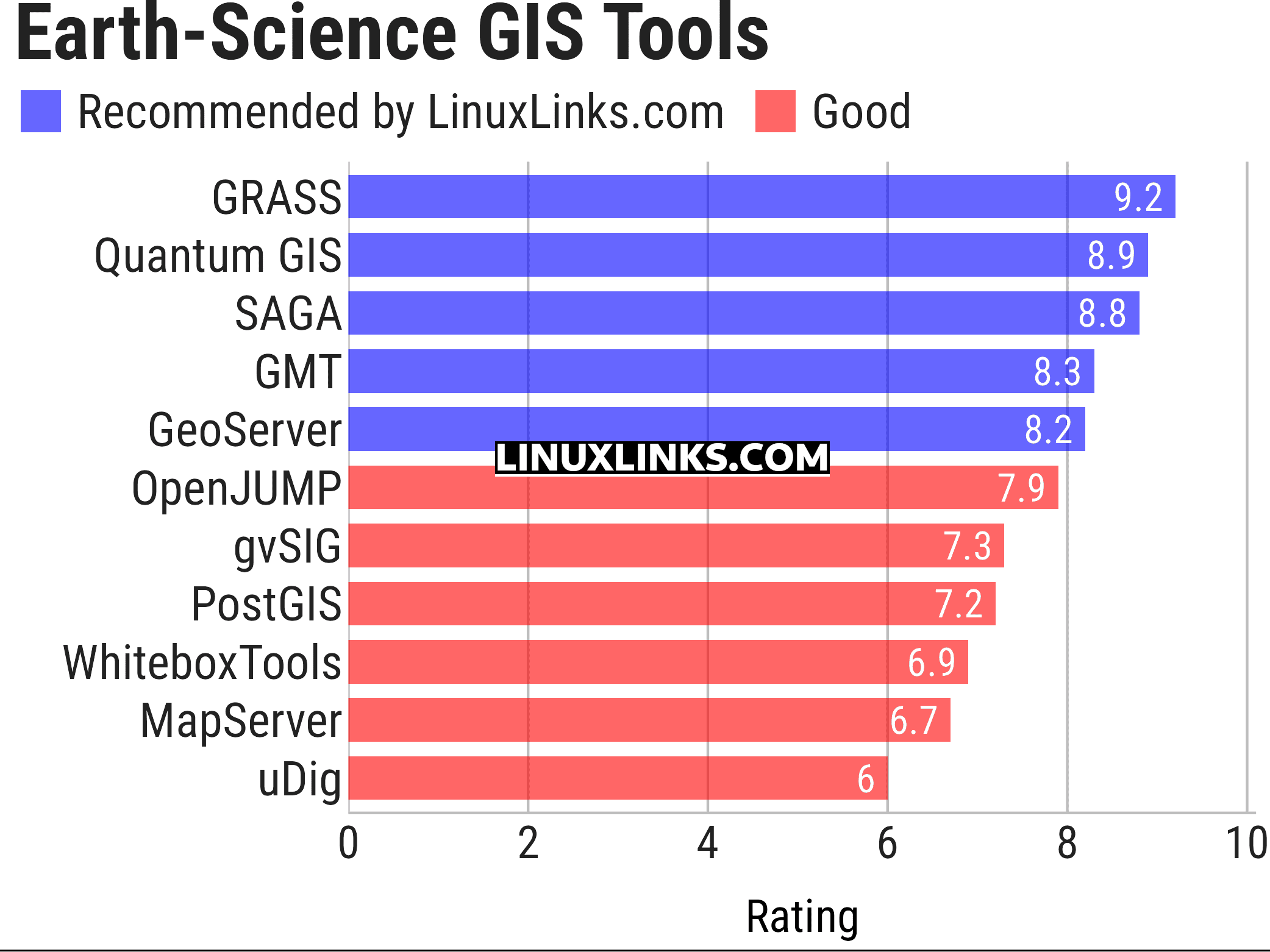
Click the links in the table below to learn all about each program.
| GIS: Earth Science Software | |
|---|---|
| GRASS | Geographic Resources Analysis Support System |
| Quantum GIS | User friendly Geographic Information System |
| SAGA | System for Automated Geoscientific Analyses |
| GMT | Collection of tools that allow users to manipulate data sets |
| GeoServer | Server written in Java that allows users to share and edit geospatial data |
| OpenJUMP | Geographic Information System written in Java |
| gvSIG Desktop | Powerful, user-friendly Geographic Information System |
| PostGIS | Database extender for PostgreSQL object-relational database |
| WhiteboxTools | Advanced geospatial data analysis platform |
| MapServer | System for developing web-based GIS applications |
| uDig | Spatial data viewer/editor |
This article has been updated to reflect the changes outlined in our recent announcement.
 Explore our comprehensive directory of recommended free and open source software. Our carefully curated collection spans every major software category. Explore our comprehensive directory of recommended free and open source software. Our carefully curated collection spans every major software category.This directory is part of our ongoing series of informative articles for Linux enthusiasts. It features hundreds of detailed reviews, along with open source alternatives to proprietary solutions from major corporations such as Google, Microsoft, Apple, Adobe, IBM, Cisco, Oracle, and Autodesk. You’ll also find interesting projects to try, hardware coverage, free programming books and tutorials, and much more. Know a useful open source Linux program that we haven’t covered yet? Let us know by completing this form. |
Please read our Comment Policy before commenting.