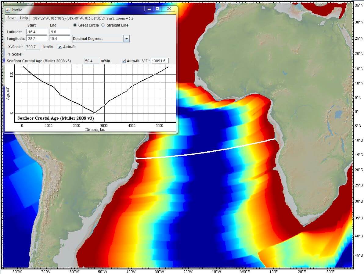
GeoMapApp is an open source, earth science exploration, global topography database, and visualization application that is continually being expanded as part of the Marine Geoscience Data System (MGDS) at the Lamont-Doherty Earth Observatory of Columbia University.
GeoMapApp relies on the internet to access a rich content of information for physical oceanography, paleoclimates, geochemistry, geology, seabed sediment and rock compositions, ocean crust age, spreading rates, bathymetry, and sediment thickness.
GeoMapApp is widely used by geoscience educators and researchers as a tool for discovering and integrating multidisciplinary earth science research data, for proposal preparation and meeting presentations and talks, for the generation of figures for publications, and for a broad range of education practices at the graduate, undergraduate and high-school level.
Features include:
- Direct access to the Global Multi-Resolution Topography (GMRT) compilation:
- Hosts high resolution (~100 m node spacing) bathymetry from multibeam data for ocean areas and ASTER (Advanced Spaceborne Thermal Emission and Reflection Radiometer) and NED (National Elevation Dataset) topography datasets for the global land masses.
- Access to over 100 data repositories:
- Basemaps:
- Global Maps.
- Regional Grids.
- Regional Maps.
- Cloud Cover.
- Geological Maps.
- Human Population.
- Land and Ocean Surface Color.
- Land Cover Classifications.
- Land Elevations.
- Land Temperatures.
- Magnetic Anomalies.
- NOAA Nautical Charts (not for navigation).
- Ocean Primary Productivity.
- Ocean Temperatures and Salinity.
- Precipitation (Rain, Snow, Ice).
- Seafloor Ages, Depths, Sediments and Spreading.
- Focus Sites:
- NSF MARGINS Program.
- NSF Ridge 2000 Program.
- Black Sea.
- Eastern Atlantic Ocean.
- Gulf of Mexico.
- Galapagos Spreading Center.
- Long Island Sound.
- Marmara Sea.
- Mediterranean Sea.
- Data Sets:
- Atmosphere and Precipitation.
- Deep Submergence Dive Locations.
- Earthquakes and Plate Boundaries.
- Heatflow Measurements.
- Hurricane Tracks.
- Ocean Crust and Sediment Acoustic Velocities.
- Oceanic Hydrothermal Vents.
- Ocean Weather Today (Waves, Air Pressure, Temperature).
- Ocean NRL-HYCOM Nowcast (Temperature, Salinity, Height and Currents).
- Past Climate and Vegetation Reconstructions.
- Seabed Sediment Color.
- Seafloor Photos.
- Seafloor Sediment Cores.
- Seafloor Sediment Composition.
- Selected Datasets from PANGAEA.
- Selected Datasets from MGDS.
- Volcanoes and Seamounts.
- Water Column Properties.
- World Data Center Paleo Climate Open Archives.
- Virtual Ocean Banner.
- Portals:
- Atmosphere and Precipitation.
- Deep Submergence Dive Locations.
- Earthquakes and Plate Boundaries.
- Heatflow Measurements.
- Hurricane Tracks.
- Ocean Crust and Sediment Acoustic Velocities.
- Oceanic Hydrothermal Vents.
- Ocean Weather Today (Waves, Air Pressure, Temperature).
- Ocean NRL-HYCOM Nowcast (Temperature, Salinity, Height and Currents).
- Past Climate and Vegetation Reconstructions.
- Seabed Sediment Color.
- Seafloor Photos.
- Seafloor Sediment Cores.
- Seafloor Sediment Composition.
- Selected Datasets from PANGAEA.
- Selected Datasets from MGDS.
- Search Expedition Data, provides a searchable map-based cruise track interface.
- Volcanoes and Seamounts.
- Water Column Properties.
- World Data Center Paleo Climate Open Archives.
- Virtual Ocean Banner.
- Overlays:
- Antarctic Ice Shelf Edge.
- Antarctic Surface Elevation Contours.
- Antarctic Graticules.
- Coastlines.
- Geographic Names.
- Human Settlements Night Lights (DMSP/NOAA).
- Lakes and Rivers.
- Watersheds (HydroSHEDS).
- Local Administrative Boundaries.
- Maritime Boundaries.
- Basemaps:
- Explore and view:
- Digital elevations.
- Earthquake data.
- Geochemistry.
- Plate motion information.
- Research cruise tracks and profiles.
- Sediment thickness grids.
- Hydrothermal vent images.
- Dedicated interfaces to explore the results of 40 years of ocean floor drilling, earthquake locations, magnitudes and epicenter depths, and seabed photographs from submersibles, remotely operated vehicles and towed camera sleds.
- Base map projection:
- Mercator.
- South Polar Selected.
- North Polar Selected.
Website: www.geomapapp.org
Support: Teaching with Data, Simulations and Models
Developer: Marine Geoscience Data System
License: Creative Commons Attribution International (CC BY) License

GeoMapApp is written in Java. Learn Java with our recommended free books and free tutorials.
| Popular series | |
|---|---|
| The largest compilation of the best free and open source software in the universe. Each article is supplied with a legendary ratings chart helping you to make informed decisions. | |
| Hundreds of in-depth reviews offering our unbiased and expert opinion on software. We offer helpful and impartial information. | |
| The Big List of Active Linux Distros is a large compilation of actively developed Linux distributions. | |
| Replace proprietary software with open source alternatives: Google, Microsoft, Apple, Adobe, IBM, Autodesk, Oracle, Atlassian, Corel, Cisco, Intuit, SAS, Progress, Salesforce, and Citrix | |
| Awesome Free Linux Games Tools showcases a series of tools that making gaming on Linux a more pleasurable experience. This is a new series. | |
| Machine Learning explores practical applications of machine learning and deep learning from a Linux perspective. We've written reviews of more than 40 self-hosted apps. All are free and open source. | |
| New to Linux? Read our Linux for Starters series. We start right at the basics and teach you everything you need to know to get started with Linux. | |
| Alternatives to popular CLI tools showcases essential tools that are modern replacements for core Linux utilities. | |
| Essential Linux system tools focuses on small, indispensable utilities, useful for system administrators as well as regular users. | |
| Linux utilities to maximise your productivity. Small, indispensable tools, useful for anyone running a Linux machine. | |
| Surveys popular streaming services from a Linux perspective: Amazon Music Unlimited, Myuzi, Spotify, Deezer, Tidal. | |
| Saving Money with Linux looks at how you can reduce your energy bills running Linux. | |
| Home computers became commonplace in the 1980s. Emulate home computers including the Commodore 64, Amiga, Atari ST, ZX81, Amstrad CPC, and ZX Spectrum. | |
| Now and Then examines how promising open source software fared over the years. It can be a bumpy ride. | |
| Linux at Home looks at a range of home activities where Linux can play its part, making the most of our time at home, keeping active and engaged. | |
| Linux Candy reveals the lighter side of Linux. Have some fun and escape from the daily drudgery. | |
| Getting Started with Docker helps you master Docker, a set of platform as a service products that delivers software in packages called containers. | |
| Best Free Android Apps. We showcase free Android apps that are definitely worth downloading. There's a strict eligibility criteria for inclusion in this series. | |
| These best free books accelerate your learning of every programming language. Learn a new language today! | |
| These free tutorials offer the perfect tonic to our free programming books series. | |
| Linux Around The World showcases usergroups that are relevant to Linux enthusiasts. Great ways to meet up with fellow enthusiasts. | |
| Stars and Stripes is an occasional series looking at the impact of Linux in the USA. | |
