The Global Positioning System (GPS) is a satellite-based navigation satellite system consisting of a network of satellites which provide positioning, navigation, and timing services in all weather, anywhere on or near the Earth.
The United States government maintains the system without levying any subscription fees or other charges.
Use of space-borne positioning and timing data is now commonplace, in everything from freight movement to synchronization of computer networks. Cellular and data networks, shipping and air transport, financial systems, railways, agriculture, and the emergency services all make frequent use of GPS. There are also many different recreational uses of GPS. The one that first springs to mind is for tracking in motor vehicles. GPS helps drivers find the best route to a specified location, summon help in the event of an emergency, plot the location of the vehicle on a map, or find the nearest bank.
GPS is also popular among other individuals constantly on the move such as mountain bikers, snowmobilers, hikers, cross-country skiers. There are so many diverse uses of GPS ranging from keeping track of vulnerable members of society, finding pets that have collars with built-in GPS, or tracking equipment while traveling. Even footballers in training are monitored and tracked by football clubs with GPS.
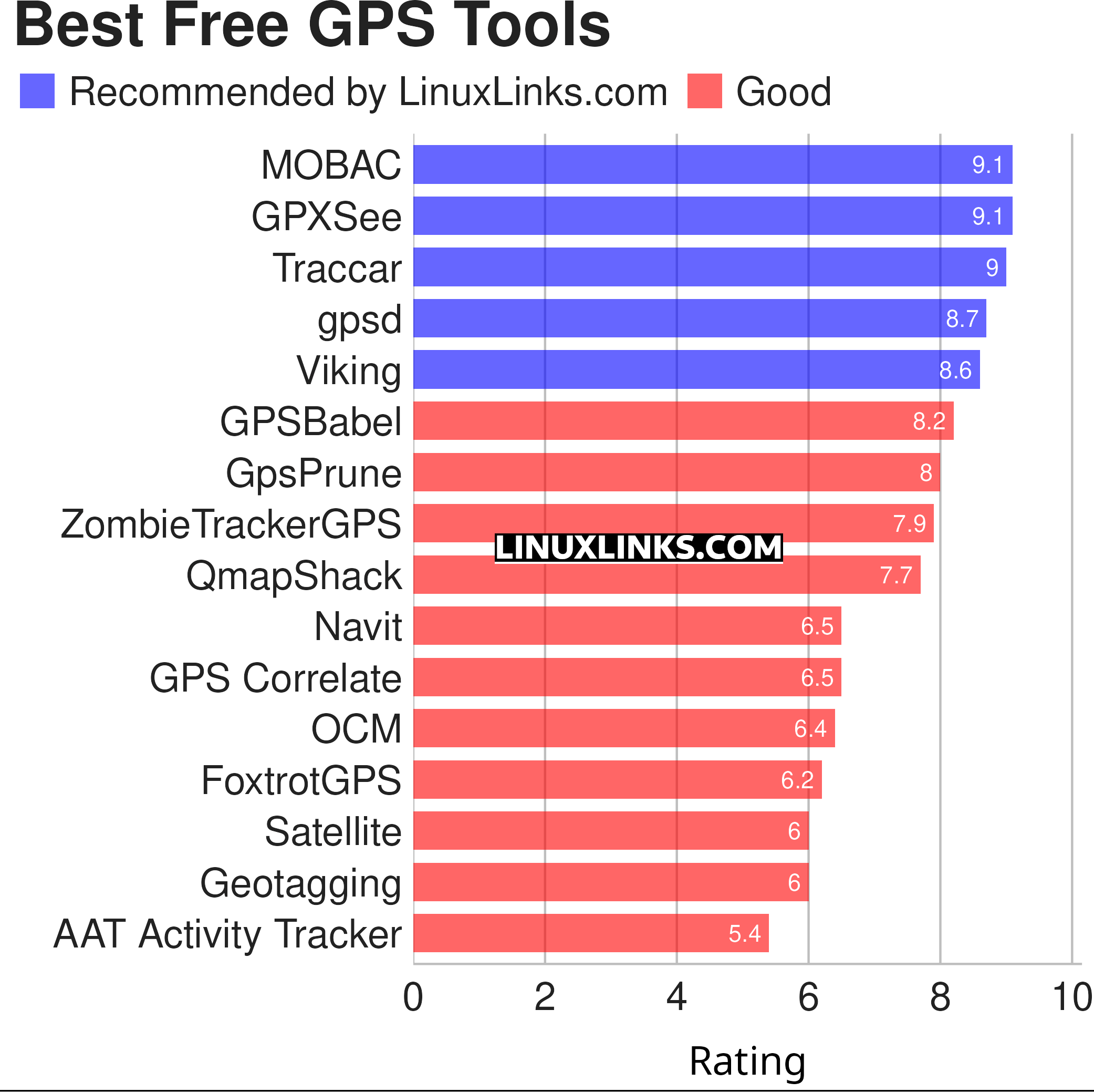
This article focuses in selecting the best free software for undertaking a wide variety of GPS related tasks. Hopefully, there will be something of interest here for anyone who needs to keep track of where they are, to find the way to a specified location, or determine what direction and how fast they are going. We make the following recommendations captured in a LinuxLinks-style ratings chart.

Let’s explore the 16 GPS tools at hand. For each application we have compiled its own portal page, providing a screenshot of the software in action, a full description with an in-depth analysis of its features, together with links to relevant resources.
| GPS Tools | |
|---|---|
| MOBAC | Create offline atlases for GPS handhelds and cell phone applications |
| GPXSee | GPS log file viewer and analyzer |
| Traccar | GPS Tracking Platform |
| gpsd | GPS service daemon |
| Viking | GPS data editor, analyzer and viewer |
| GPSBabel | GPS file conversion plus transfer to/from GPS units |
| GpsPrune | View, edit, and convert coordinate data from GPS systems |
| ZombieTrackerGPS | Fitness and GPS track manager designed for KDE |
| QMapShack | GPS mapping (GeoTiff and vector) and GPSr management |
| Navit | Car navigation system with routing engine |
| GPS Correlate | Correlates digital images with GPS data filling EXIF fields |
| Open Cache Manager | Easy to use program for managing your geocaches |
| FoxtrotGPS | GPS/GIS application designed for small screens |
| Satellite | Displays GNSS information obtained from NMEA sources |
| Geotagging | Photography geotagging tool |
| AAT Activity Tracker | Tracking sportive activities, with an emphasis on cycling |
This article has been revamped in line with our recent announcement.
 Read our complete collection of recommended free and open source software. Our curated compilation covers all categories of software. Read our complete collection of recommended free and open source software. Our curated compilation covers all categories of software. Spotted a useful open source Linux program not covered on our site? Please let us know by completing this form. The software collection forms part of our series of informative articles for Linux enthusiasts. There are hundreds of in-depth reviews, open source alternatives to proprietary software from large corporations like Google, Microsoft, Apple, Adobe, IBM, Cisco, Oracle, and Autodesk. There are also fun things to try, hardware, free programming books and tutorials, and much more. |
