
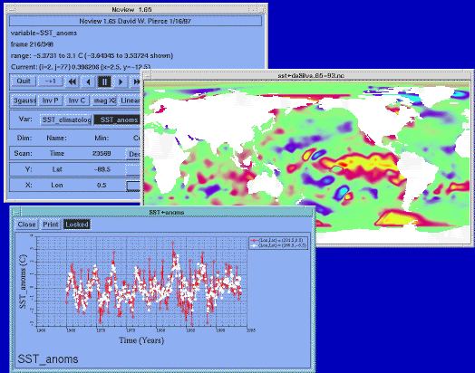
ncview is open source software to get a quick and easy viewer for NetCDF files.
With this application, you can view simple movies of the data, view along various dimensions, take a look at the actual data values, change color maps, invert the data and other simple visual operations.
ncview depends on netcdf version 4 will full HDF5 support.
Key Features
- Displays a 2-dimensional, color representation of data in a netCDF file.
- Useful for quickly inspecting model data.
- Animate the data in time (making simple movies).
- Flip the picture.
- Enlarge the picture.
- Scan through various axes.
- Change colourmaps.
- Plot the data in X-Y plots.
- udunits support – time axes that use the conventions in the udunits package.
Website: cirrus.ucsd.edu/ncview
Support:
Developer: David W. Pierce
License: GNU General Public License v3.0
ncview is written in C. Learn C with our recommended free books and free tutorials.
Related Software
| Earth Science Software | |
|---|---|
| GRASS | Geographic Resources Analysis Support System |
| Quantum GIS | User friendly Geographic Information System |
| Survex | Cave surveying and mapping software |
| SAGA | System for Automated Geoscientific Analyses |
| GPlates | Interactive visualization of plate-tectonics |
| GMT | Collection of tools that allow users to manipulate data sets |
| Therion | Cave surveying - 2D and 3D drawing software |
| GeoServer | Server written in Java that allows users to share and edit geospatial data |
| OpenJUMP | Geographic Information System written in Java |
| GrADS | Grid Analysis and Display System for earth science data |
| gvSIG Desktop | Powerful, user-friendly Geographic Information System |
| PostGIS | Database extender for PostgreSQL object-relational database |
| WhiteboxTools | Advanced geospatial data analysis platform |
| ObsPy | Framework to process, analyse, and visualise seismological data |
| ncview | Visual browser for NetCDF format files |
| MapServer | System for developing web-based GIS applications |
| OpenDrift | Framework for ocean trajectory modelling |
| MetPy | Read, visualize and perform calculations with weather data |
| uDig | Spatial data viewer/editor |
| OpenSees | Open System for Earthquake Engineering Simulation |
| Grock | Displays a geological map of the UK |
Read our verdict in the software roundup.
 Explore our comprehensive directory of recommended free and open source software. Our carefully curated collection spans every major software category. Explore our comprehensive directory of recommended free and open source software. Our carefully curated collection spans every major software category.This directory is part of our ongoing series of informative articles for Linux enthusiasts. It features hundreds of detailed reviews, along with open source alternatives to proprietary solutions from major corporations such as Google, Microsoft, Apple, Adobe, IBM, Cisco, Oracle, and Autodesk. You’ll also find interesting projects to try, hardware coverage, free programming books and tutorials, and much more. Discovered a useful open source Linux program that we haven’t covered yet? Let us know by completing this form. |