
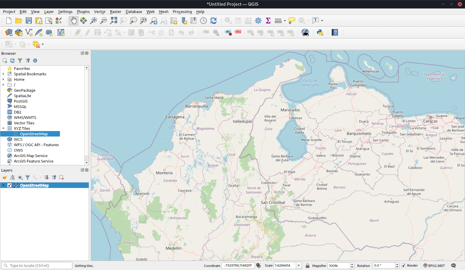
QGIS is a desktop geographic information system (GIS) for working with geospatial data. It brings data viewing, cartography, editing, analysis, database access and publishing together in a single application.
It works directly with a broad range of vector, raster, mesh, database and web-service sources, avoiding the need to convert everything into a proprietary internal format. Projects can combine data from many sources and present it through detailed 2D or 3D map views, layouts and reports.
This is free and open source software.
Key Features
- Reads and writes widely used vector and database formats including GeoPackage, Shapefile, GeoJSON, PostGIS, SpatiaLite, Microsoft SQL Server Spatial and Oracle Spatial.
- Displays raster and imagery formats through GDAL, along with mesh data, vector tiles, spreadsheets and temporal datasets.
- Connects to OGC web services including WMS, WMTS, WCS, WFS and WFS-T.
- Provides extensive digitising and editing tools with snapping, geometry operations, attribute tables, forms and topology checking.
- Includes sophisticated labelling, symbology, annotations, spatial bookmarks, map decorations and data-defined styling.
- Offers print layouts, reports and atlas generation for producing publication-quality cartographic output.
- Includes a georeferencer, GPS tools, OpenStreetMap support and tools for managing spatial databases.
- Provides a comprehensive Processing framework for native algorithms and tools from projects such as GDAL and GRASS GIS.
- Includes a graphical modeller for chaining processing steps into repeatable workflows and supports batch processing.
- Supports terrain, raster, vector, geometry, network and database analysis, with processing tasks able to run in the background.
- Extensible through a large plugin ecosystem and an integrated Python console for scripting and automation.
Website: www.qgis.org
Support:
Developer: QGIS Development Team
License: GNU General Public License v2.0
QGIS is written in C++. Learn C++ with our recommended free books and free tutorials. Learn Python with our recommended free books and free tutorials.
Related Software
| GIS: Earth Science Software | |
|---|---|
| GRASS | Geographic Resources Analysis Support System |
| Quantum GIS | User friendly Geographic Information System |
| SAGA | System for Automated Geoscientific Analyses |
| GMT | Collection of tools that allow users to manipulate data sets |
| GeoServer | Server written in Java that allows users to share and edit geospatial data |
| OpenJUMP | Geographic Information System written in Java |
| gvSIG Desktop | Powerful, user-friendly Geographic Information System |
| PostGIS | Database extender for PostgreSQL object-relational database |
| WhiteboxTools | Advanced geospatial data analysis platform |
| MapServer | System for developing web-based GIS applications |
| uDig | Spatial data viewer/editor |
Read our verdict in the software roundup.
| Virtual Globes | |
|---|---|
| Quantum GIS | User friendly Geographic Information System |
| OpenStreetMap | A copyright free alternative to Google Maps |
| Marble | Combination atlas/virtual globe |
| GeoMapApp | Earth science exploration, global topography database, and visualization |
| osgEarth | C++ toolkit for rendering geospatial data in 3D |
| World Wind | Virtual globe initially developed by NASA's Learning Technologies project |
| TerriaMap | Build and deploy web-based geospatial data explorers |
| ossimPlanet | Accurate 3D global geo-spatial viewer |
Read our verdict in the software roundup.
| Mapping Tools | |
|---|---|
| Organic Maps | Offline maps & GPS app for hiking, cycling, biking, and driving |
| CoMaps | Community-led maps and navigation application |
| QGIS | GIS that supports vector, raster, and database formats |
| Marble | Virtual globe and world atlas |
| Placemark | Web-based tool for geospatial data |
| Maputnik | Visual editor for creating and editing MapLibre map styles |
| JOSM | Extensible editor for OpenStreetMap |
| uMap | Web application for creating and publishing custom interactive maps |
| Map | Wardley map editor |
| Kadas Albireo | Mapping application based on QGIS targeted at non-specialized users |
| TuiView | Lightweight raster GIS |
| Pure Maps | Native map and navigation application |
| Merkaartor | OpenStreetMap mapping program |
| GNOME Maps | Find places around the world |
| FacilMap | Collaborative map for planning and sharing locations |
| VersaTiles | Generate, process, store, serve, and render map tiles |
| osmin | GPS navigator for on-road and off-road navigation |
| OpenStreetBrowser | Browse and explore OpenStreetMap data by category |
| Maps | Lightweight map viewer for exploring places and locations |
Read our verdict in the software roundup.
 Explore our carefully curated directory of recommended free and open source software, covering every major software category. Explore our carefully curated directory of recommended free and open source software, covering every major software category.The directory forms part of our extensive collection of articles for Linux enthusiasts. It includes hundreds of detailed reviews, together with free and open source alternatives to proprietary software from companies such as Google, Microsoft, Apple, Adobe, IBM, Cisco, Oracle, and Autodesk. LinuxLinks also covers interesting projects worth exploring, Linux-compatible hardware, free programming books and tutorials, and much more. Know a useful free and open source Linux application that we haven’t covered? Tell us about it using our submission form. |
Please read our Comment Policy before commenting.